History Alphabet
is for BAWBURGH!
There have been many variations of the name Bawburgh. In the Domesday Book it was spelt Baunburc, and the following were recorded by the early historian, Francis Blomefield in his ‘History of Norfolk’ published in 1739. The spellings were copied from registries and documents dating back to the 11th century - Baber, Bawburc, Bauburgh, Baburgh, Bauburc, Baburc, Baubure, Barber, Bawbure, Babure, Banburgh and Bavenburc. The village was called Bauburgh on the 1836 OS Map and Bawbridge on the 1904 OS map.The following information comes from the Norfolk Historic Environment Record of the county’s archaeological sites – 'The name probably means enclosure, farmstead or stronghold belonging to Beawa or Gadfly. Gadfly may be a nickname.The name is old English in origin, suggesting there was a Saxon settlement here.’
For this and other information see the following website -Heritage Norfolk page for Bawburgh
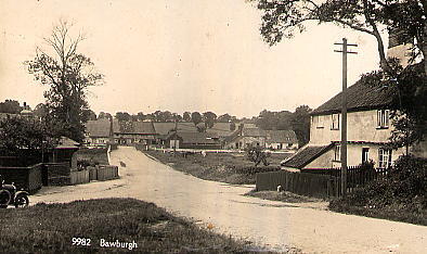 A telegraph pole had arrived, when this postcard was printed -
probably
during the 1930s. But shows little change from today!
A telegraph pole had arrived, when this postcard was printed -
probably
during the 1930s. But shows little change from today!
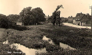
When this was taken around 1930 there were three Black Poplars,
and
the river was rather overgrown!
B is also for the Iconic Bawburgh Bridge
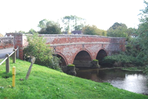
Not so much an iconic building, but an iconic structure, so pivotal as it is, having joined the divisions of “north and south” Bawburgh for nearly 200 years, each claiming to be “upper Bawburgh”! Seriously, it is well used and well loved. Its status as a Scheduled Ancient Monument (Number Norfolk 348) applied in 1976 confirms its importance. It is also No. 12721 on the Sites and Monuments Record at the Norfolk Landscape Archaeology unit, at Gressenhall Museum. It is described as an “Arched structure of stone and brick” but a visit in 1977 declared it “not worthy of comment”. How dare they! However, when the Bridge was re-visited in 1979, it was suitably declared “A pleasant bridge—but not outstanding”. Better. For your detailed information, the County Surveyor in 1866 measured its three semi-circular arches, the centre arch with a 16’3” span, and the outer arches of 13’8”. It is coned with 6” saddleback Portland stone and the roadway is 13’8” wide, the parapet being 3’8” above the road. The present bridge replaced a previous one built during the early 1600s. It was another 200 years before the present bridge was built, in 1815, and was the subject of work by divers late in the 1800s, when presumably the iconic cross ties were fixed. More recent repairs took place in 2007, which hopefully will sustain our iconic central symbol. Although a weight limit does exist, there is no way the daily load it now endures could have been predicted when it was built in 1815.
B is also for Blacksmiths Cottage
See the Iconic Buildings page for details
B is also for Bawburgh Hall
The death of Stephen Vincent of Wramplingham Hall in October 2016, brought to mind his connections to Bawburgh. In 1954 he bought Bawburgh Hall (see H for Hall) and it was the beginning of the use of that land as a Duck Farm. His wife's family business of Henry Beales of Ellingham had encouraged the interest but the state of the Hall was deteriorating, since the grants available at the time did not meet the cost of restoration of the 300 year old building. It was left to deteriorate, until it was finally deemed unsafe and allowed to be demolished in 1963. The Duck Farm has continued to be a presence and employer in the village ever since, under changing ownership from Beales to Buxted, Kerry Foods to Bressingham Ducks. Hall Farm Place was built on the site of Bawburgh Hall in 1980.